A quote by Jim Whittaker- First American to Summit Mt Everest 1963
"If you are not living on the edge, than your taking up too much space"

wan·der·lust/ˈwändərˌləst Noun: A strong desire to travel: "a woman consumed by wanderlust".
Wednesday, May 30, 2012
Monday, May 28, 2012
"32" challenge update
As of the end of Memorial weekend this is where I stand:
5/28/12
Total Hikes: 9
Total miles: 66
Total Elevation: 21,800 ft climbed
The elevation is not the difficult part, clearly I am an adrenaline junky. Now I just need to pick up the pace a little and make up for a lazy fall and winter (not totally lazy since I had over 30 days on snow this year).
13 weekends left before the 33rd birthday (and the "33" challenge begins).
You do the math....
Hikes left: 23 *average 2 a weekend (but a few backpacking trips could knock this down)
Total Miles: 254 *that's an average of 11 miles a hike (22 miles a weekend)
Elevation: 10, 200 *piece of cake
Nada Lake- The Enchantments 5.27.12
Nada Lake, The Enchantments- Leavenworth, WA#9, 10 miles, 3550 ft

The drive out to Leavenworth took much longer than I would have liked and considering the length of the hike I wish I had arrived at the trailhead earlier than 11:30. The Drive went from Seattle gloom and rain to clear blue skies mid 70s in the Wenatchee Forest. When in doubt of Seattle weather just head east for the sun and warm air.
Trailhead parking lot (elev 1300 ft) was nearly full and I suspect 80% of the vehicles were overnight backpackers who have been lucky enough to obtain the very elusive overnight permits that are regulated based on a lottery in to the enchantment lakes area.
 The
first mile is a steady switchback climb on a hot and dusty slope
scattered with lupines, lillies, penstemons and the sweet fragrance of
the earth warming up after a cold harsh winter.
The
first mile is a steady switchback climb on a hot and dusty slope
scattered with lupines, lillies, penstemons and the sweet fragrance of
the earth warming up after a cold harsh winter.
As you "officially" enter the alpine lakes wilderness the trail looses some of the shade due to a scorched hillside from a fire years past. But what it does offer is extraordinary views along the snow creek canyon.
Start traversing up along the base of wedge mountain but keep your eyes and ears out for mountain goats. Many of these majestic creatures call wedge mountain home and after reading the WTA trip reports of a few weeks prior I was in high alert.

It wasn't long before I had my first spotting. If I hadnt been so hyper aware I may have missed him standing on his throne about 200 ft above me. Some of the trip reports had warned that these majestic and very large creatures were agressively charging hikers on the trail. I kept my eye on this guy as I creeped closer up the trail.
He never did get very close and after a few switchbacks I lost sight of him. But I still felt responsible to warn other fellow hikers, who seemed unaware of the potential dangers of these charging creatures.
Later up the trail a few miles another woman said she spotted a large Bull charging 2 campers trapped yelling from a tree.

About 3 miles in I hit some scattered patches of snow (elevation 3600 ft) but the trail was still relatively clear.
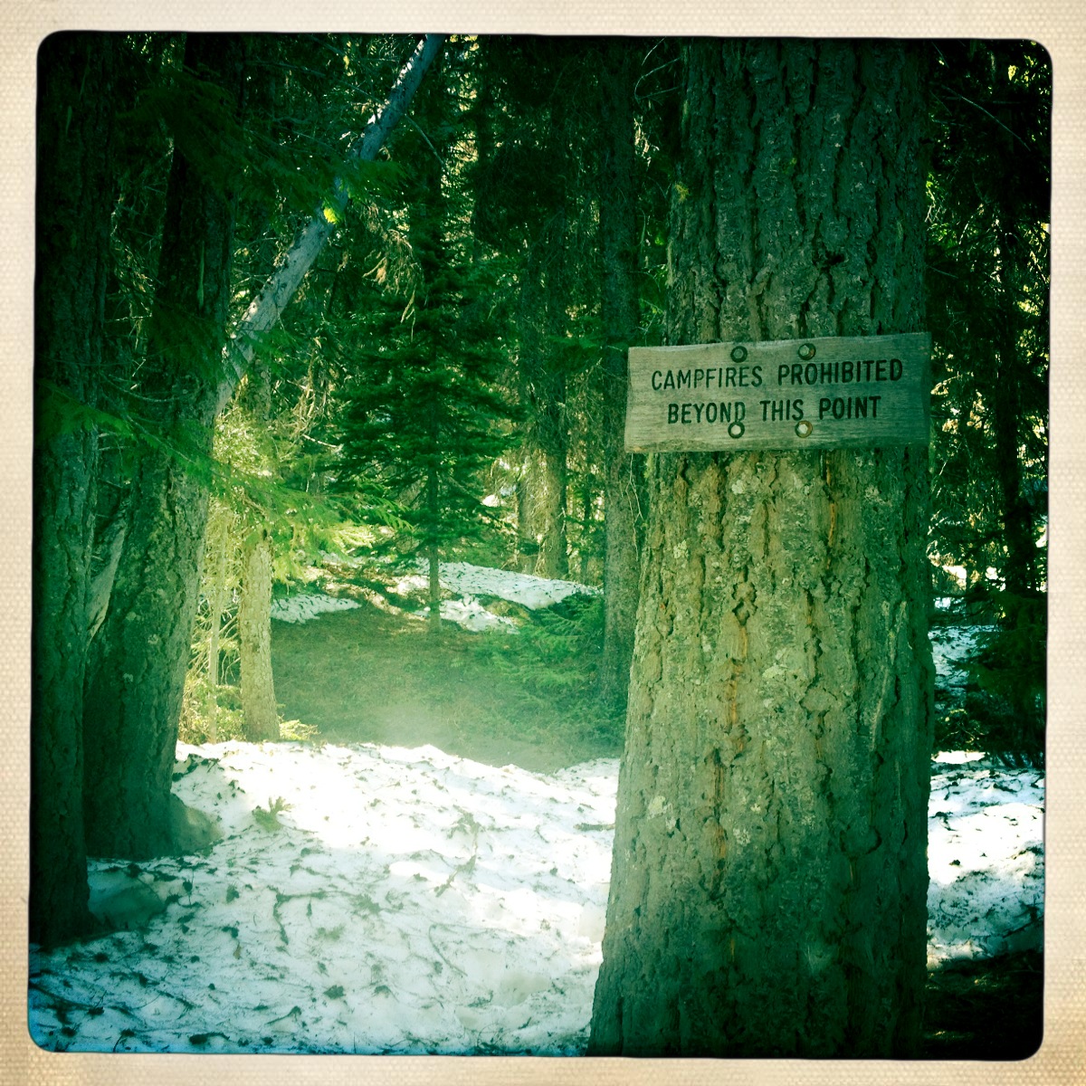
It wasnt until the bridge crossing (4200 ft) over snow creek that the real snow terrain began. The trail is easy to follow and heavy with boot tracks but in some spots the snow is so dirty and old that it is hard to tell and can get a bit disorientating and could use some better tree markers.
 It
wasn't until I saw this sign "campfires prohibited beyond this point"
that I felt confident I was heading in the right direction.
It
wasn't until I saw this sign "campfires prohibited beyond this point"
that I felt confident I was heading in the right direction.
A good thing to remember when backpacking into the alpine lake regions is to get aquaintined with the rules and regulatons. This should be applied for any trip you are planning into any national parks and wilderness regions.
These "rules" are in place to keep safe the delicate ecosystems that can easily be damamged by humans carelessness. Most wilderness areas will have postings for backpackers: no fires above 5000 ft and within 1/2 mile of many pristine lake basins. When in doubt contact the local ranger station.

From the Snow creek crossing to Nada lake is very wet, muddy and snowy. Most of the trail is more like a creek with melting snow and hard snowpack.
As I was making the final approach towards Nada lake I felt the shift in the late afternoon sun. Its always the rush for a late start day to try and make it to your destination and safely back out before night fall. Some of the granite rock slide ridges were still heavy with snow pack and took careful maneuvering to keep safe footing.

Nada Lake was still mostly frozen over and despite the snow coverage was in the 60s. There was a large flat rock slab next to the lakes edge where some campers were sprawled out cooking an early dinner and enjoying the late afternoon sun. A part of me was experiencing a tinge of jelousy and wished I was setting up camp instead of scarfing down my food to hurry up and head back down the mtn before night fall.


I reached the parking lot about 6:30 and headed as fast as I could into Leavenworth. Its starting to become my ritual to treat myself to local fare wherever I am. Either before or after a hike I like to familiarize myself with a local cafe, bar or restaurant. I found myself at the Leavenworth Sausage Garten by Cured. A Brat, potato salad and a pale ale. Extra Jalepanos please!!!

The drive out to Leavenworth took much longer than I would have liked and considering the length of the hike I wish I had arrived at the trailhead earlier than 11:30. The Drive went from Seattle gloom and rain to clear blue skies mid 70s in the Wenatchee Forest. When in doubt of Seattle weather just head east for the sun and warm air.
Trailhead parking lot (elev 1300 ft) was nearly full and I suspect 80% of the vehicles were overnight backpackers who have been lucky enough to obtain the very elusive overnight permits that are regulated based on a lottery in to the enchantment lakes area.

As you "officially" enter the alpine lakes wilderness the trail looses some of the shade due to a scorched hillside from a fire years past. But what it does offer is extraordinary views along the snow creek canyon.
Start traversing up along the base of wedge mountain but keep your eyes and ears out for mountain goats. Many of these majestic creatures call wedge mountain home and after reading the WTA trip reports of a few weeks prior I was in high alert.

It wasn't long before I had my first spotting. If I hadnt been so hyper aware I may have missed him standing on his throne about 200 ft above me. Some of the trip reports had warned that these majestic and very large creatures were agressively charging hikers on the trail. I kept my eye on this guy as I creeped closer up the trail.
He never did get very close and after a few switchbacks I lost sight of him. But I still felt responsible to warn other fellow hikers, who seemed unaware of the potential dangers of these charging creatures.
Later up the trail a few miles another woman said she spotted a large Bull charging 2 campers trapped yelling from a tree.
 |
| short break to snack and enjoy the view |
 |
| fields of wild orchids scatter the trails |

About 3 miles in I hit some scattered patches of snow (elevation 3600 ft) but the trail was still relatively clear.
It wasnt until the bridge crossing (4200 ft) over snow creek that the real snow terrain began. The trail is easy to follow and heavy with boot tracks but in some spots the snow is so dirty and old that it is hard to tell and can get a bit disorientating and could use some better tree markers.
 It
wasn't until I saw this sign "campfires prohibited beyond this point"
that I felt confident I was heading in the right direction.
It
wasn't until I saw this sign "campfires prohibited beyond this point"
that I felt confident I was heading in the right direction.A good thing to remember when backpacking into the alpine lake regions is to get aquaintined with the rules and regulatons. This should be applied for any trip you are planning into any national parks and wilderness regions.
These "rules" are in place to keep safe the delicate ecosystems that can easily be damamged by humans carelessness. Most wilderness areas will have postings for backpackers: no fires above 5000 ft and within 1/2 mile of many pristine lake basins. When in doubt contact the local ranger station.
 |
| panoramic view of Wedge Mtn |

From the Snow creek crossing to Nada lake is very wet, muddy and snowy. Most of the trail is more like a creek with melting snow and hard snowpack.
As I was making the final approach towards Nada lake I felt the shift in the late afternoon sun. Its always the rush for a late start day to try and make it to your destination and safely back out before night fall. Some of the granite rock slide ridges were still heavy with snow pack and took careful maneuvering to keep safe footing.
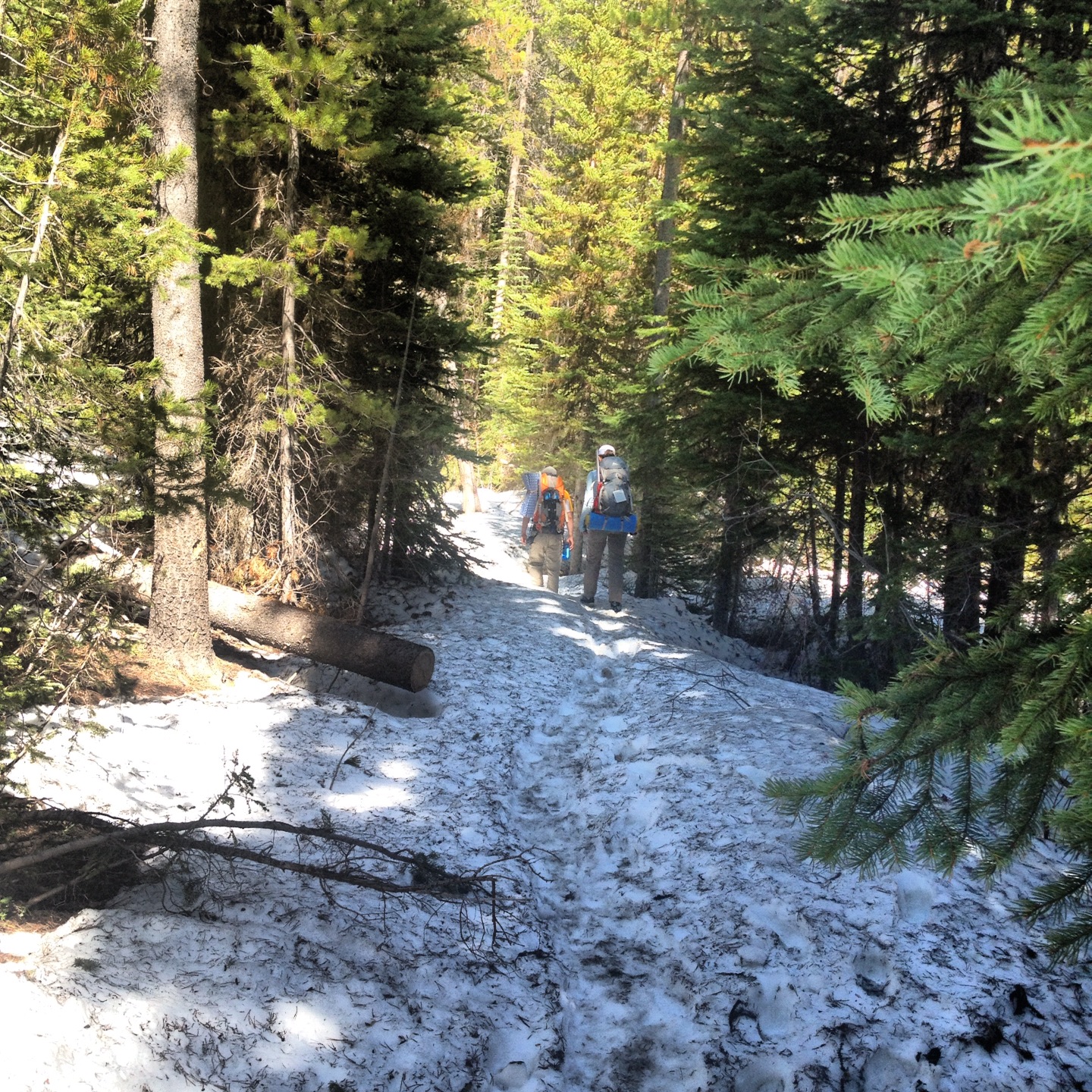 |
| Backpackers heading out from Snow Lake. |

Nada Lake was still mostly frozen over and despite the snow coverage was in the 60s. There was a large flat rock slab next to the lakes edge where some campers were sprawled out cooking an early dinner and enjoying the late afternoon sun. A part of me was experiencing a tinge of jelousy and wished I was setting up camp instead of scarfing down my food to hurry up and head back down the mtn before night fall.
 |
| View across Nada lake |


I reached the parking lot about 6:30 and headed as fast as I could into Leavenworth. Its starting to become my ritual to treat myself to local fare wherever I am. Either before or after a hike I like to familiarize myself with a local cafe, bar or restaurant. I found myself at the Leavenworth Sausage Garten by Cured. A Brat, potato salad and a pale ale. Extra Jalepanos please!!!
Saturday, May 26, 2012
Mt Si (Old Big Si Trail)-5.26.12
Mt Si via the Old Big Si Trail
#8, 7 miles, 3700 ft
Summit 3980
 Mount Si has been calling my name all winter as I passed it a hundred times up and down the mtn pass to either Snoqualmie or the many Idaho trips. It is the pinnacle peak as you head up the 90 corridor. With its sheer rock face and steep elevation gain it offers the best views and the easiest access from the city. Again, like rattlesnake, you will be battling the crowds on a clear weekend.
The trick I have discovered to bypass the main Si trail is start from little Si and take the boulder garden loop. Boulder Garden loop starts about .3 miles from the trail head off to the right. This is a fairly easy loop gaining just under a 1000 ft in elevation. At 1.2 miles you reach the Old Big Si trail where the real hike begins.
 On a beautiful clear Saturday I only passed 2 people on the way up and a handful who were coming down. Maybe the steeper and shorter route is what makes this trail a hidden gem.
2120 ft elevation in 2.2 miles.
This trail intercepts the main trail in two places just below the basin and as soon as you reach the summit and haystack you realize how many people who do not know this secret. So please don't spread the word.
As soon as I had entered the trail I met a guy who matched my speed and we were passing slow moving families huffing and puffing as we made our summit push.

Summit views were amazing and families and groups of people were scattered across the rocks.
Every boulder seemed to be occupied with picnickers, photo taking, book reading or just enjoying the view. I made my way over the boulder scramble and headed toward the haystacks.
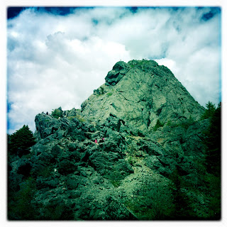


Elevation at the basin of the haystacks is 3980 with another 220 ft gained from a nearly sheer face scramble. It is very tempting for people of all skill levels and that is why extra caution should be taken when scrambling next to people pushing themselves beyond their skill or comfort level. On this day the appeal of such amazing views makes for a very busy rock face. Careless climbers are kicking loose rocks and not paying attn in there hurry.


I made my way about halfway up before I realized there was too many people attempting fairly technical terrain after nearly getting taken out by a loose rock. The gentleman I had met earlier on the trail agreed. Its not a matter of your own skill level but assesing those around you. And deciding how comftorable you are given all of the variable factors beyond your control.
It was slightly dissapointing and even a bit of a let down to climb only half way up just to turn around after climbing nearly 3500 ft....but oh well. Would rather live to climb again.

#8, 7 miles, 3700 ft
Summit 3980
 Mount Si has been calling my name all winter as I passed it a hundred times up and down the mtn pass to either Snoqualmie or the many Idaho trips. It is the pinnacle peak as you head up the 90 corridor. With its sheer rock face and steep elevation gain it offers the best views and the easiest access from the city. Again, like rattlesnake, you will be battling the crowds on a clear weekend.
The trick I have discovered to bypass the main Si trail is start from little Si and take the boulder garden loop. Boulder Garden loop starts about .3 miles from the trail head off to the right. This is a fairly easy loop gaining just under a 1000 ft in elevation. At 1.2 miles you reach the Old Big Si trail where the real hike begins.

2120 ft elevation in 2.2 miles.
This trail intercepts the main trail in two places just below the basin and as soon as you reach the summit and haystack you realize how many people who do not know this secret. So please don't spread the word.
As soon as I had entered the trail I met a guy who matched my speed and we were passing slow moving families huffing and puffing as we made our summit push.

Summit views were amazing and families and groups of people were scattered across the rocks.
Every boulder seemed to be occupied with picnickers, photo taking, book reading or just enjoying the view. I made my way over the boulder scramble and headed toward the haystacks.


Elevation at the basin of the haystacks is 3980 with another 220 ft gained from a nearly sheer face scramble. It is very tempting for people of all skill levels and that is why extra caution should be taken when scrambling next to people pushing themselves beyond their skill or comfort level. On this day the appeal of such amazing views makes for a very busy rock face. Careless climbers are kicking loose rocks and not paying attn in there hurry.


I made my way about halfway up before I realized there was too many people attempting fairly technical terrain after nearly getting taken out by a loose rock. The gentleman I had met earlier on the trail agreed. Its not a matter of your own skill level but assesing those around you. And deciding how comftorable you are given all of the variable factors beyond your control.
It was slightly dissapointing and even a bit of a let down to climb only half way up just to turn around after climbing nearly 3500 ft....but oh well. Would rather live to climb again.

 |
| One guy nearly got stuck wedged in a crack. |
 |
| Favorite end of hike treat. |
Sunday, May 20, 2012
Rattlesnake Ledge-5.20.12
Rattlesnake Ledge-
#7, 5 miles, 1200 ft
 Rattlesnake ledge and/or ridge is not a hike that has held much appeal for me. I have read many of the posts regarding it as the "Super Highway" of trails (along with Si). It seems to be the most easily accessible full nature trail close to Seattle and the surrounding outskirts. Even on a rainy Saturday the trail was bustling with hikers of all kinds.
About half way up to the ledge I am passing an elderly gentleman from Korea. He immediately starts talking to me as if I knew him. Its something I have started to appreciate as a solo hiker when you open your self up to stories from complete strangers. I allowed myself to get swept up with the stories of his life as a child in Korea for about 15 min. After which I thanked him and continued up at my original pace.

 After enjoying a moment I left the ledge and headed towards the East Peak. Stepping back on to the trail I was nearly trampled by a group of 10 who were
carrying umbrellas and not paying very close attention to who was down
trail from them. They clearly felt regardless of uphill vs down hill
right-of-way that you were just in the way. One of my least favorite aspects of this trail.
After enjoying a moment I left the ledge and headed towards the East Peak. Stepping back on to the trail I was nearly trampled by a group of 10 who were
carrying umbrellas and not paying very close attention to who was down
trail from them. They clearly felt regardless of uphill vs down hill
right-of-way that you were just in the way. One of my least favorite aspects of this trail.
 Soon after leaving the ledge the trail becomes a little more desolate. Most casual hikers just come up for the short 2 mile viewing spot. The only other person I ran into was a nice German man who stopped to chat me up about my favorite hiking spots. After at least 45 min of standing in the rain and swapping stories I decided to make this my turn around point and join Chris. We spent the next 4 miles chatting away like old friends.
That's the magic of trail bonding. It doesn't take much before you have reached common ground and bonded over similar interests. You cant even get this much social interaction from a bar in downtown Seattle. It takes getting out into the woods to actually crack through the icy "Seattle Freeze".

#7, 5 miles, 1200 ft
 Rattlesnake ledge and/or ridge is not a hike that has held much appeal for me. I have read many of the posts regarding it as the "Super Highway" of trails (along with Si). It seems to be the most easily accessible full nature trail close to Seattle and the surrounding outskirts. Even on a rainy Saturday the trail was bustling with hikers of all kinds.
About half way up to the ledge I am passing an elderly gentleman from Korea. He immediately starts talking to me as if I knew him. Its something I have started to appreciate as a solo hiker when you open your self up to stories from complete strangers. I allowed myself to get swept up with the stories of his life as a child in Korea for about 15 min. After which I thanked him and continued up at my original pace.


 |
| The Super highway of trails |

That's the magic of trail bonding. It doesn't take much before you have reached common ground and bonded over similar interests. You cant even get this much social interaction from a bar in downtown Seattle. It takes getting out into the woods to actually crack through the icy "Seattle Freeze".

Sunday, May 13, 2012
Snoquera Falls-5.13.12
Snoquera Falls- South Cascades, Chinook Pass
#5, 5 miles, 1500 ft
My first hike back out on the trail since last fall and I was eager and hungry to stretch my legs. Despite the beauty and height of the falls I felt more than a little disapointed when it seemed the trail abruptly ended. It seemed the trail turned and twisted back across the rock slide and I thought it would lead me back around the falls but instead dumped you back on the main trail just below. In a moment of confusion I went back to base of the falls and stared across the roaring spring runoff. I couldent quite tell but it seemed the trail cut across...but I was a little curious. So I made 3 seperate attempts to try and scramble over and around the slippery boulders scattered across the creek bed. After the 3rd try I decided not to press my luck and just call it a day.


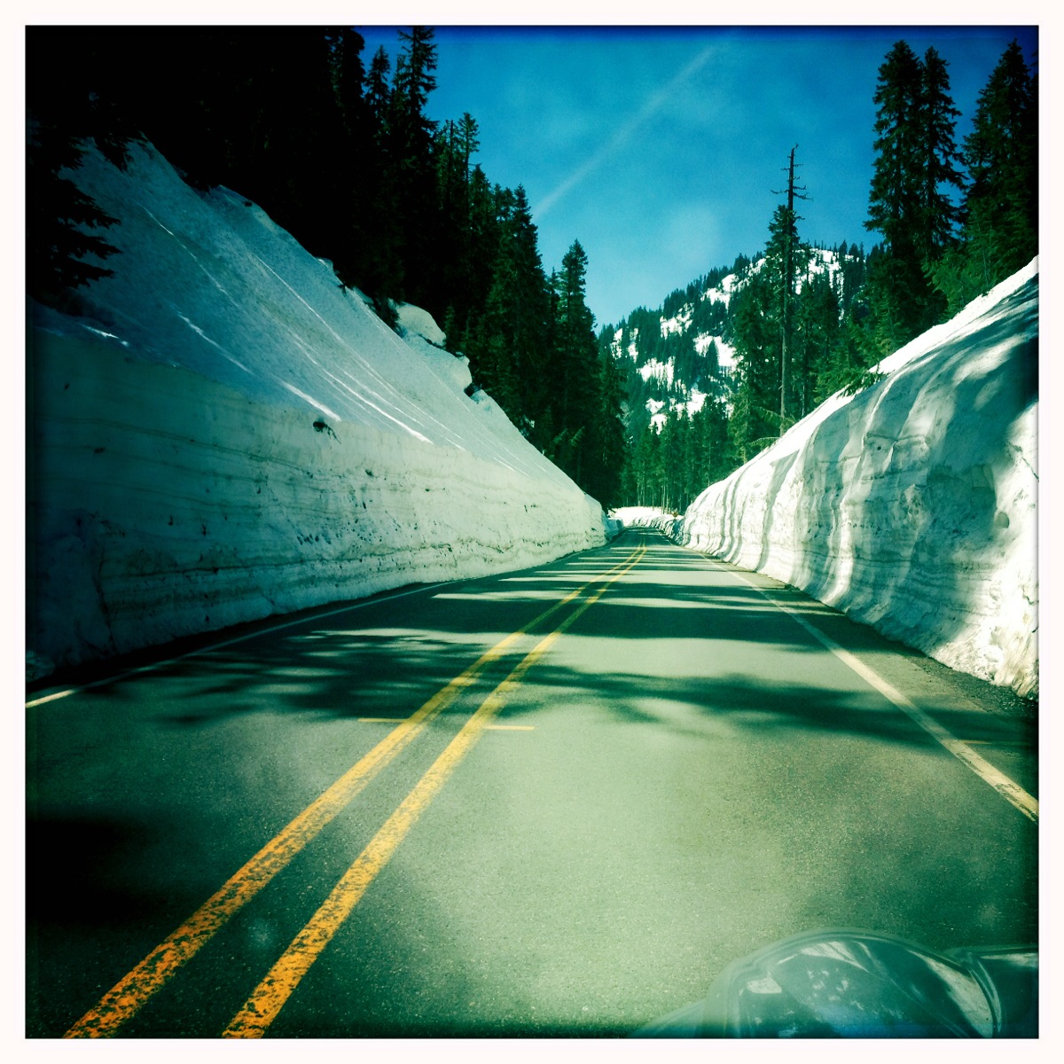
 Leaving the trailhead at 10:00am I decided to head towards Rainier to enjoy some clear views. The road to Rainier National Park was open and made for a nice morning drive.


 While heading down Hwy 410 I noticed several cars parked off the road at what looked like a trailhead just past the snoquera road.
Palisades Trail
#6, 8 miles, 2800 ft
Beautiful trail that meanders along the Ranger Creek.


#5, 5 miles, 1500 ft
My first hike back out on the trail since last fall and I was eager and hungry to stretch my legs. Despite the beauty and height of the falls I felt more than a little disapointed when it seemed the trail abruptly ended. It seemed the trail turned and twisted back across the rock slide and I thought it would lead me back around the falls but instead dumped you back on the main trail just below. In a moment of confusion I went back to base of the falls and stared across the roaring spring runoff. I couldent quite tell but it seemed the trail cut across...but I was a little curious. So I made 3 seperate attempts to try and scramble over and around the slippery boulders scattered across the creek bed. After the 3rd try I decided not to press my luck and just call it a day.


Palisades Trail
#6, 8 miles, 2800 ft
Beautiful trail that meanders along the Ranger Creek.


Subscribe to:
Posts (Atom)